
ODD IMAGES
ON GOOGLE EARTH
that's right, and it's here to stay, you bet. now, I like to use
Google Earth for work on a regular basis, especially since I
work in a major metropolitan area (higher resolution pics),
as well as the fact that GE has a very accurate ruler tool,
which I can use to measure up buildings. amazing. free. yup.
so, today... amongst the beginnings of whispers that the old
internets are slowly and gradually becoming (at least partly)
sentient, we're gonna have a Big Blog look at Google Earth.
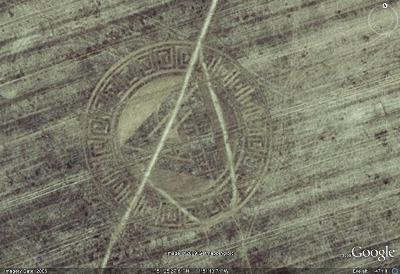
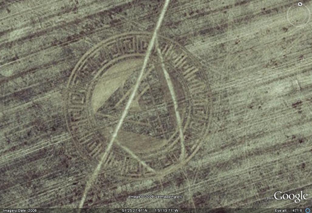
there's a ton of fucked up images in there, ya know... what,
and not just the stuff like the old Crop Circle up top, there
(51° 25' 28.35" N, 1° 51' 19.97" W), and, yes, those are the
coordinates to load into the GE search bar to fly there. if ya
don't have it yet, grab it here... it is a fucking gas, I'm here
to tell ya. oh, yeah. all the images posted on here today are
click-to-enrage, for a quick close up; but, we've also loaded
in the coordinates to nearly all of 'em... so' y'all can plug 'em
in your own GE and play along, so to speak. that's right, there
is no photo-fuckery goin' on here, today, no-siree-Bob! these
are all screenshots I got whilst investigating a fucking gaggle
of the so-called odd or strange images and places. you can
also find more info, fan sites and hacker groups on the web.
oh, my... I'm rambling on, huh? yeah, it's pretty cool, dat.
come on, why don't ya? let's go for a little scroll, shall we?
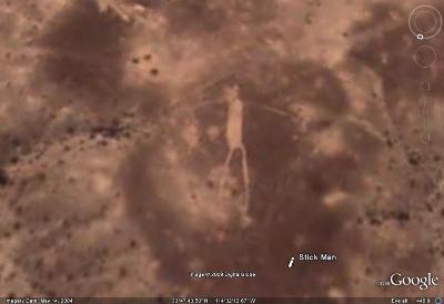
this oddball is known only as "Stick Man". go figure.
33 ° 47' 43.56" N, 114° 32' 12.63" W

here's a shot of he Pyramids at Giza. yup. ya know, oddly enough,
though, old Shpynxter-Boy, there, didn't show well from overhead...
29°58'44.54"N, 31° 8'2.45"E
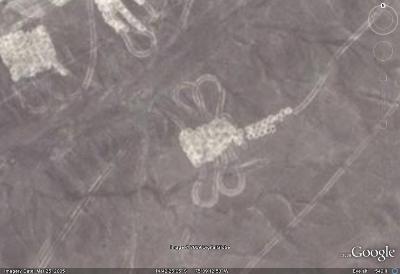
... but, this did~ the Dragonfly from the Nazca Desert in Peru.
14°42'25.01"S, 75° 9'12.35"W

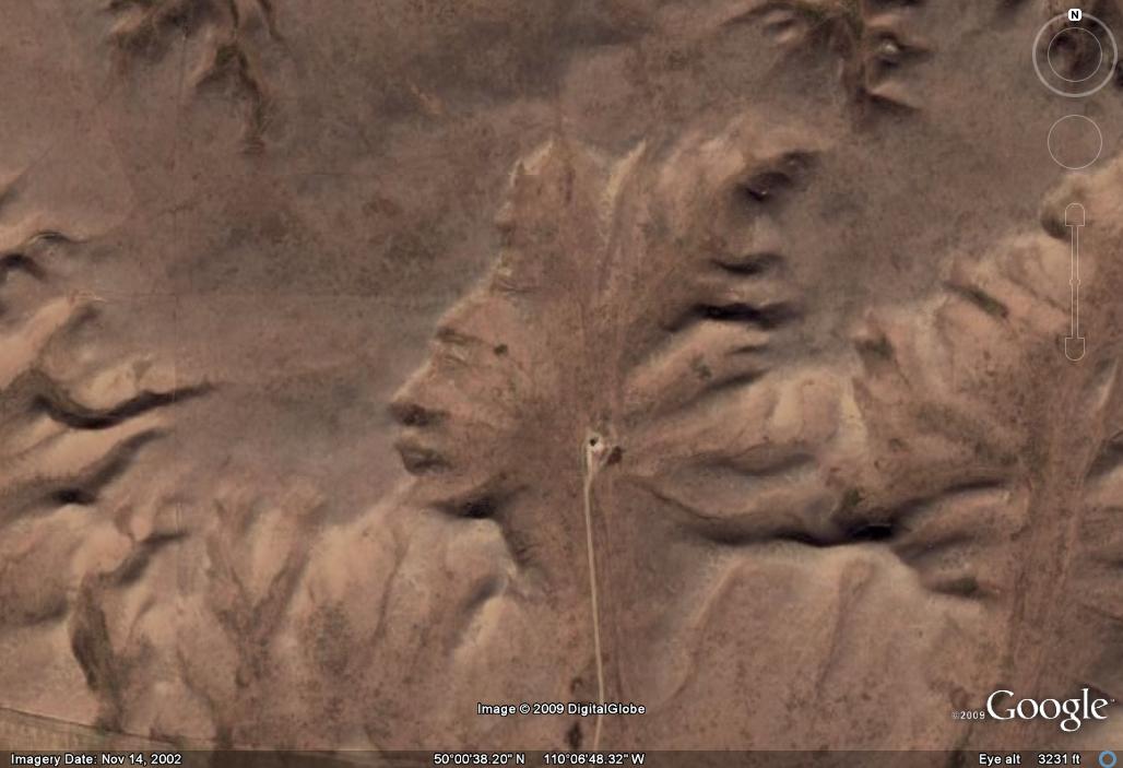
check out this magnificent son-of-a-bitch from the land of
the Great White North, "Guardian of the Badlands", yup.
this, from Alberta, Canada (eh?) and not at all from the U.S.
50° 0'38.20"N, 110° 6'48.32"W

'course, you can always go South of the Border, as well...
as in, South, to Puerto Rico, which is where you'll find this
huge radio telescope, that the locals like to call, "El Radar"...
18° 20' 39.28" N, 66° 45' 10.30" W

you need to go back to America, though, to find these
crazy-assed and entirely radar-lookin' Crop circles...
39°41'21.12"N, 116° 0'6.81"W

... as well as these buildings which are leanin' into each other.
47°36'47.45"N, 122°20'2.04"W
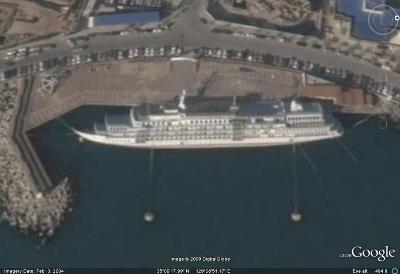
speaking of leanin', I wonder what's wrong with this boat?
35° 9'18.10"N, 129° 8'50.35"E

oh, I get it. she must have run aground on these underwater
giant blocks of fucking submerged stone. yup, that'll do it...
43° 17' 27.72" N, 140° 38' 08.66" E
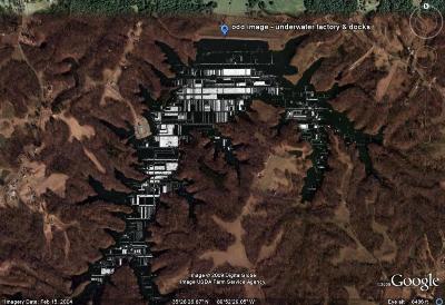
... and, here's an underwater factory from Cyber Legend CJ Sorg.
35°28'51.58"N, 89°52'28.54"W

ya know, ya just gotta love a 200-foot giant pink bunny that's
been constructed on an Alpen hillside. oh, those crazy Italians.
44° 14' 39.43" N, 7° 46' 10.69" E
being spy photos and all, sometimes GE releases pics
which have been taken at the most inopportune times...
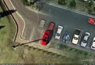
... like during this suave mother fucker of a parking job...
33°46'52.38"S, 151°17'18.87"E
... but, he's got nothin' on this guy here, though, lemme tell ya.
52° 4'9.18"N, 4°18'50.35"E

click to enrage this "Flying Car" from Down Under.
sorry, it's gone from the GE database. file photo, only...

... but not this swell mother fucker of a crash scene, boyo!
46°45'56.41"N, 100°47'33.85"W

here's an extremely cool shot of a plane refueling in mid-air.
41°51'7.41"N, 121°28'44.61"W

hey, they even caught a Tomahawk Missile on celluloid!
38°13'36.20"N, 112°17'56.53"W

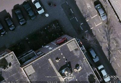
this guy here, though, is about to be in big trouble.
sorry ~ file photo only, this one.

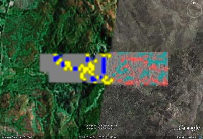
occasinally, there's minor glitches in the GE database, which
blends multiple images together like a collage in the browser...
51°28'18.60"N, 0°28'55.93"W

... so, ya sometimes get stuff like these Color Bars, you bet...
51°44'58.02"N, 60°38'2.42"E
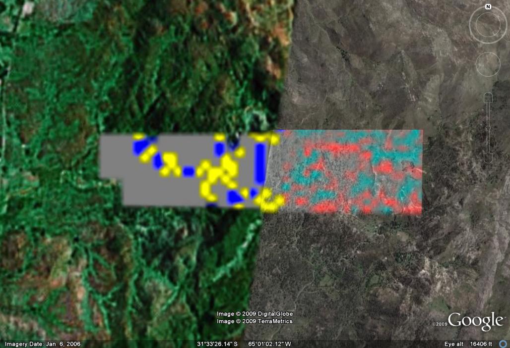
... or this one here, which I like to call "Error 404". LOL...
31°34'1.00"S, 65° 1'18.89"W
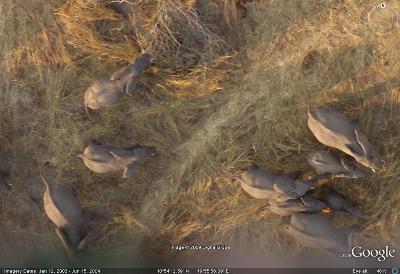
... but, for the most part, Google Earth just delivers the goods,
like in this spectacular shot of a herd of Elephants in Africa.
10°54'13.66"N, 19°56'6.15"E

we here at unbalanced would like to take just a moment to say
thanks to our sponsor for this week, Kentucky Fucky Chicken.
uh, thanks a lot, there, Colonel Sanders, Mother Fucker. yup.
yes, you'll find this one here... 37°38'46.00"N, 115°45'4.71"W
see ya next week...
last week's Big Blog
ON GOOGLE EARTH
that's right, and it's here to stay, you bet. now, I like to use
Google Earth for work on a regular basis, especially since I
work in a major metropolitan area (higher resolution pics),
as well as the fact that GE has a very accurate ruler tool,
which I can use to measure up buildings. amazing. free. yup.
so, today... amongst the beginnings of whispers that the old
internets are slowly and gradually becoming (at least partly)
sentient, we're gonna have a Big Blog look at Google Earth.
there's a ton of fucked up images in there, ya know... what,
and not just the stuff like the old Crop Circle up top, there
(51° 25' 28.35" N, 1° 51' 19.97" W), and, yes, those are the
coordinates to load into the GE search bar to fly there. if ya
don't have it yet, grab it here... it is a fucking gas, I'm here
to tell ya. oh, yeah. all the images posted on here today are
click-to-enrage, for a quick close up; but, we've also loaded
in the coordinates to nearly all of 'em... so' y'all can plug 'em
in your own GE and play along, so to speak. that's right, there
is no photo-fuckery goin' on here, today, no-siree-Bob! these
are all screenshots I got whilst investigating a fucking gaggle
of the so-called odd or strange images and places. you can
also find more info, fan sites and hacker groups on the web.
oh, my... I'm rambling on, huh? yeah, it's pretty cool, dat.
come on, why don't ya? let's go for a little scroll, shall we?
this oddball is known only as "Stick Man". go figure.
33 ° 47' 43.56" N, 114° 32' 12.63" W
here's a shot of he Pyramids at Giza. yup. ya know, oddly enough,
though, old Shpynxter-Boy, there, didn't show well from overhead...
29°58'44.54"N, 31° 8'2.45"E
... but, this did~ the Dragonfly from the Nazca Desert in Peru.
14°42'25.01"S, 75° 9'12.35"W
check out this magnificent son-of-a-bitch from the land of
the Great White North, "Guardian of the Badlands", yup.
this, from Alberta, Canada (eh?) and not at all from the U.S.
50° 0'38.20"N, 110° 6'48.32"W
'course, you can always go South of the Border, as well...
as in, South, to Puerto Rico, which is where you'll find this
huge radio telescope, that the locals like to call, "El Radar"...
18° 20' 39.28" N, 66° 45' 10.30" W
you need to go back to America, though, to find these
crazy-assed and entirely radar-lookin' Crop circles...
39°41'21.12"N, 116° 0'6.81"W
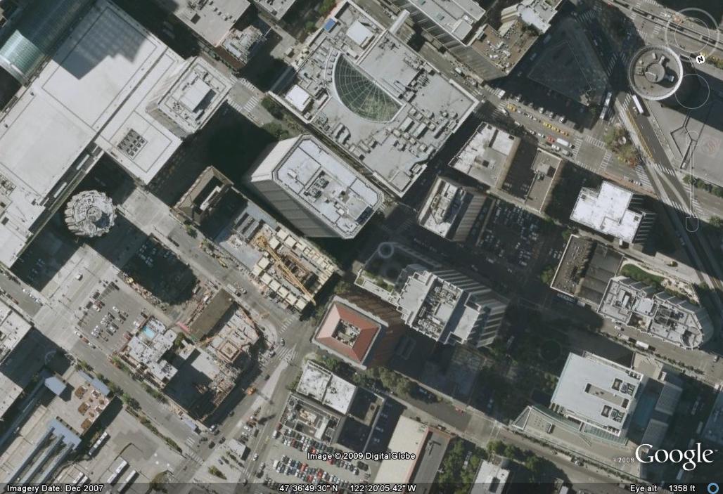
... as well as these buildings which are leanin' into each other.
47°36'47.45"N, 122°20'2.04"W
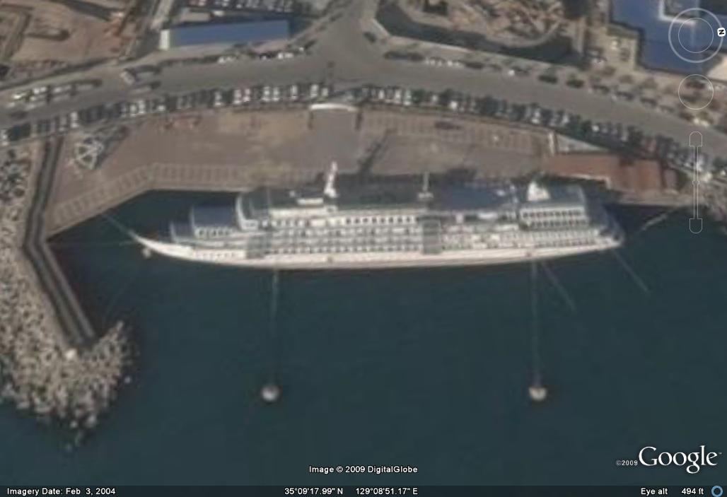
speaking of leanin', I wonder what's wrong with this boat?
35° 9'18.10"N, 129° 8'50.35"E
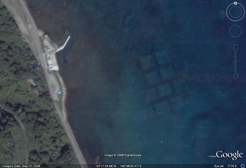
oh, I get it. she must have run aground on these underwater
giant blocks of fucking submerged stone. yup, that'll do it...
43° 17' 27.72" N, 140° 38' 08.66" E
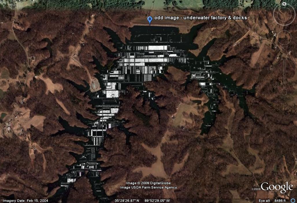
... and, here's an underwater factory from Cyber Legend CJ Sorg.
35°28'51.58"N, 89°52'28.54"W
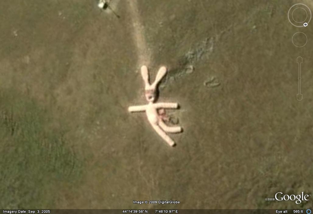
ya know, ya just gotta love a 200-foot giant pink bunny that's
been constructed on an Alpen hillside. oh, those crazy Italians.
44° 14' 39.43" N, 7° 46' 10.69" E
being spy photos and all, sometimes GE releases pics
which have been taken at the most inopportune times...
... like during this suave mother fucker of a parking job...
33°46'52.38"S, 151°17'18.87"E
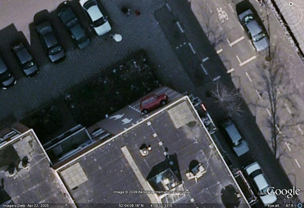
... but, he's got nothin' on this guy here, though, lemme tell ya.
52° 4'9.18"N, 4°18'50.35"E
click to enrage this "Flying Car" from Down Under.
sorry, it's gone from the GE database. file photo, only...
... but not this swell mother fucker of a crash scene, boyo!
46°45'56.41"N, 100°47'33.85"W
here's an extremely cool shot of a plane refueling in mid-air.
41°51'7.41"N, 121°28'44.61"W
hey, they even caught a Tomahawk Missile on celluloid!
38°13'36.20"N, 112°17'56.53"W
this guy here, though, is about to be in big trouble.
sorry ~ file photo only, this one.
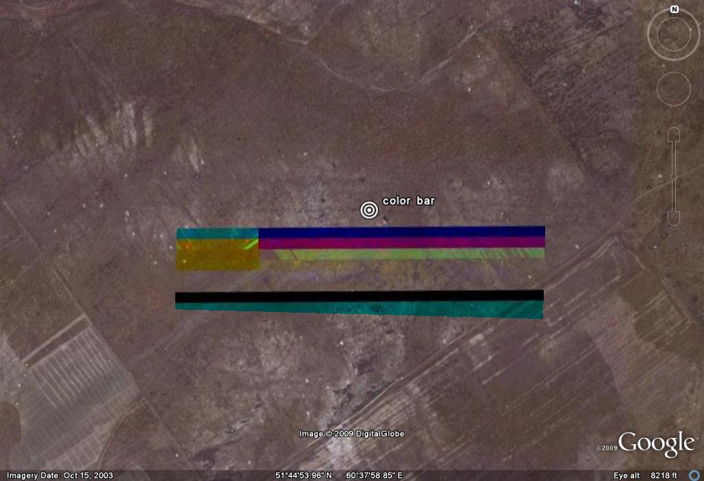
occasinally, there's minor glitches in the GE database, which
blends multiple images together like a collage in the browser...
51°28'18.60"N, 0°28'55.93"W
... so, ya sometimes get stuff like these Color Bars, you bet...
51°44'58.02"N, 60°38'2.42"E
... or this one here, which I like to call "Error 404". LOL...
31°34'1.00"S, 65° 1'18.89"W
... but, for the most part, Google Earth just delivers the goods,
like in this spectacular shot of a herd of Elephants in Africa.
10°54'13.66"N, 19°56'6.15"E
we here at unbalanced would like to take just a moment to say
thanks to our sponsor for this week, Kentucky Fucky Chicken.
uh, thanks a lot, there, Colonel Sanders, Mother Fucker. yup.
yes, you'll find this one here... 37°38'46.00"N, 115°45'4.71"W
see ya next week...
last week's Big Blog
ON GOOGLE EARTH
that's right, and it's here to stay, you bet. now, I like to use
Google Earth for work on a regular basis, especially since I
work in a major metropolitan area (higher resolution pics),
as well as the fact that GE has a very accurate ruler tool,
which I can use to measure up buildings. amazing. free. yup.
so, today... amongst the beginnings of whispers that the old
internets are slowly and gradually becoming (at least partly)
sentient, we're gonna have a Big Blog look at Google Earth.
there's a ton of fucked up images in there, ya know... what,
and not just the stuff like the old Crop Circle up top, there
(51° 25' 28.35" N, 1° 51' 19.97" W), and, yes, those are the
coordinates to load into the GE search bar to fly there. if ya
don't have it yet, grab it here... it is a fucking gas, I'm here
to tell ya. oh, yeah. all the images posted on here today are
click-to-enrage, for a quick close up; but, we've also loaded
in the coordinates to nearly all of 'em... so' y'all can plug 'em
in your own GE and play along, so to speak. that's right, there
is no photo-fuckery goin' on here, today, no-siree-Bob! these
are all screenshots I got whilst investigating a fucking gaggle
of the so-called odd or strange images and places. you can
also find more info, fan sites and hacker groups on the web.
oh, my... I'm rambling on, huh? yeah, it's pretty cool, dat.
come on, why don't ya? let's go for a little scroll, shall we?

this oddball is known only as "Stick Man". go figure.
33 ° 47' 43.56" N, 114° 32' 12.63" W

here's a shot of he Pyramids at Giza. yup. ya know, oddly enough,
though, old Shpynxter-Boy, there, didn't show well from overhead...
29°58'44.54"N, 31° 8'2.45"E

... but, this did~ the Dragonfly from the Nazca Desert in Peru.
14°42'25.01"S, 75° 9'12.35"W
check out this magnificent son-of-a-bitch from the land of
the Great White North, "Guardian of the Badlands", yup.
this, from Alberta, Canada (eh?) and not at all from the U.S.
50° 0'38.20"N, 110° 6'48.32"W

'course, you can always go South of the Border, as well...
as in, South, to Puerto Rico, which is where you'll find this
huge radio telescope, that the locals like to call, "El Radar"...
18° 20' 39.28" N, 66° 45' 10.30" W
you need to go back to America, though, to find these
crazy-assed and entirely radar-lookin' Crop circles...
39°41'21.12"N, 116° 0'6.81"W
... as well as these buildings which are leanin' into each other.
47°36'47.45"N, 122°20'2.04"W
speaking of leanin', I wonder what's wrong with this boat?
35° 9'18.10"N, 129° 8'50.35"E
oh, I get it. she must have run aground on these underwater
giant blocks of fucking submerged stone. yup, that'll do it...
43° 17' 27.72" N, 140° 38' 08.66" E
... and, here's an underwater factory from Cyber Legend CJ Sorg.
35°28'51.58"N, 89°52'28.54"W
ya know, ya just gotta love a 200-foot giant pink bunny that's
been constructed on an Alpen hillside. oh, those crazy Italians.
44° 14' 39.43" N, 7° 46' 10.69" E

being spy photos and all, sometimes GE releases pics
which have been taken at the most inopportune times...
... like during this suave mother fucker of a parking job...
33°46'52.38"S, 151°17'18.87"E
... but, he's got nothin' on this guy here, though, lemme tell ya.
52° 4'9.18"N, 4°18'50.35"E
click to enrage this "Flying Car" from Down Under.
sorry, it's gone from the GE database. file photo, only...

... but not this swell mother fucker of a crash scene, boyo!
46°45'56.41"N, 100°47'33.85"W

here's an extremely cool shot of a plane refueling in mid-air.
41°51'7.41"N, 121°28'44.61"W

hey, they even caught a Tomahawk Missile on celluloid!
38°13'36.20"N, 112°17'56.53"W

this guy here, though, is about to be in big trouble.
sorry ~ file photo only, this one.

occasinally, there's minor glitches in the GE database, which
blends multiple images together like a collage in the browser...
51°28'18.60"N, 0°28'55.93"W
... so, ya sometimes get stuff like these Color Bars, you bet...
51°44'58.02"N, 60°38'2.42"E
... or this one here, which I like to call "Error 404". LOL...
31°34'1.00"S, 65° 1'18.89"W
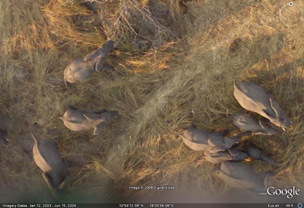
... but, for the most part, Google Earth just delivers the goods,
like in this spectacular shot of a herd of Elephants in Africa.
10°54'13.66"N, 19°56'6.15"E
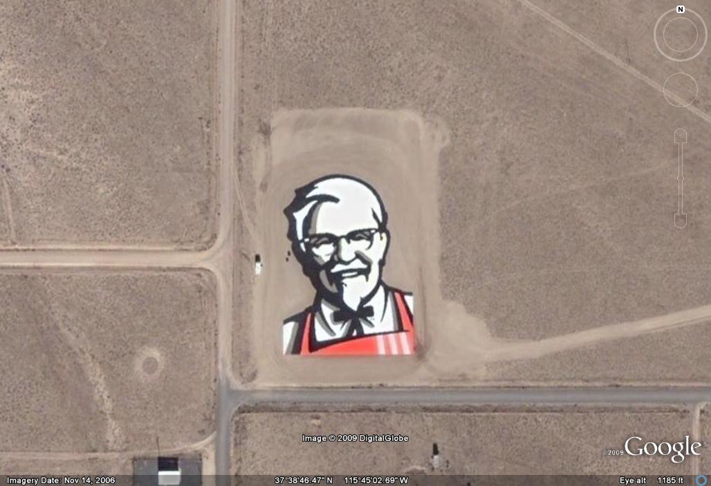
we here at unbalanced would like to take just a moment to say
thanks to our sponsor for this week, Kentucky Fucky Chicken.
uh, thanks a lot, there, Colonel Sanders, Mother Fucker. yup.
yes, you'll find this one here... 37°38'46.00"N, 115°45'4.71"W
see ya next week...
last week's Big Blog
expunged by doctor chip @ 1:36 PM
![]()


2 Comments:
That was fucking cool!
Wow...great post. I followed along with Google Earth. Fun!
Love the mini on the wall:
http://www.panoramio.com/photo/19591087
The KFC logo was only there for about two weeks..near area 51. Apparently the tiles the used to make it kept blowing away...or aliens took them.
http://bbs.keyhole.com/ubb/ubbthreads.php?ubb=showflat&Number=685706&site_id=1#import
Post a Comment
<< Home